

GLMRIS Frequently Asked Questions (FAQ)
- What is GLMRIS?
- Why is GLMRIS important?
- What are the major activities that have been completed in GLMRIS?
- Why has USACE selected a specific site for further evaluation in GLMRIS?
- How was the Brandon Road site selected?
- What is USACE currently working on?
- Will this effort automatically lead to construction of new controls?
- What is being considered?
- What types of controls could be implemented now?
- Why can’t the Corps just hurry up and build something?
- How would a possible project at Brandon Road impact navigation?
- How much is this going to cost and how long will it take?
GLMRIS Report FAQ
- What is the purpose of the GLMRIS Report?
- What species are currently of greatest concern?
- How did you determine the species and technologies presented in the GLMRIS Report?
- What types of alternatives are described in the GLMRIS Report?
- What are nonstructural controls?
- What is hydrologic separation?
- What technologies are proposed in the GLMRIS Report to control ANS transfer?
- How effective are each of the proposed ANS controls?
- Could the alternative plans impact other uses or users of the waterways?
- How much time would it take to implement the alternative plans?
- How much money would it take to implement the alternative plans?
- Which alternative plan does USACE recommend?
- How did USACE communicate the findings of the GLMRIS Report?
- How did USACE use public comments on the GLMRIS Report?
- What did USACE hear from stakeholders and the public?
Other ANS Efforts FAQ
- Besides GLMRIS, what are the current efforts of USACE to prevent aquatic nuisance species (ANS) from establishing sustainable populations in the Great Lakes?
- How do the electric barriers work?
- Are the barriers effective?
- Where are the carp?
- How does USACE monitor the location of Asian carp?
- What is eDNA, and how is USACE using it?
GLMRIS FAQ
What is GLMRIS?
In Section 3061(d) of the Water Resources Development Act of 2007, Congress directed the Secretary of the Army, acting through the Chief of Engineers, to conduct a study evaluating a range of options and technologies available to prevent the transfer of aquatic nuisance species (ANS) between the Great Lakes and Mississippi River basins via aquatic pathways.
The U.S. Army Corps of Engineers (USACE) is conducting the Great Lakes & Mississippi River Interbasin Study (GLMRIS) in consultation with other federal agencies, Native American tribes, state agencies, local governments and nongovernmental organizations. The Chicago Area Waterway System is Focus Area I of GLMRIS, as it is the primary, continuous aquatic connection between the Mississippi River basin and the Great Lakes. Focus Area II is comprised of 18 pathways that have potential to become inter-basin transfer sites during flood events or other high-water conditions.
Why is GLMRIS important?
As a result of international commerce, travel and local practices, ANS have been introduced and have spread throughout the Great Lakes and Mississippi River basins. ANS threaten the diversity and abundance of native species; threaten the ecological stability of infested waters; or threaten the commercial, agricultural or recreational activities dependent on such waters.
What are the major activities that have been completed in GLMRIS?
In January 2014, the GLMRIS Report was issued to Congress and the public. The report includes an array of eight alternatives at the conceptual design level with a range of cost estimates. Activities that were accomplished in order to compile the GLMRIS Report include:
- Inventory of current conditions (economic, environmental and social) and discussion of possible future conditions within the study area;
- Identification of aquatic pathways that may exist between the Great Lakes and Mississippi River basins;
- Inventory of current and future potential ANS;
- Evaluation of possible ANS controls to prevent ANS transfer, to include hydrologic separation of the basins;
- Assessment of impacts each ANS control may have on significant natural resources and existing and forecasted uses of the lakes and waterways within the study area.
For additional information on the GLMRIS Report, please visit the GLMRIS Report page. FAQs about the GLMRIS Report are listed above.
Why has USACE selected a specific site for further evaluation in GLMRIS?
The GLMRIS Report demonstrates that implementation of the most effective range of alternatives to control ANS transfer would require a substantial investment of time and money. Given the potential urgency of the threat of ANS – with particular attention to Asian carp species – and in response to a growing consensus among Congressional, nongovernmental, and public stakeholders, the Assistant Secretary of the Army for Civil Works, in coordination with the USACE study team, determined that further investigation of possible interim measures is an appropriate next step in GLMRIS.
How was the Brandon Road site selected?
The Brandon Road control point was identified in the GLMRIS analyses as a single location that can address upstream transfer of Mississippi River species through all CAWS pathways. Implementation of technologies at the Brandon Road control point was a feature of three out of six structural alternatives presented in the GLMRIS Report. This location also serves as a valuable control point for species of particular public and stakeholder concern – the Silver and Bighead carp. Placement of technologies at – or downstream of – the Brandon Road lock structure enhances effectiveness of the controls by incorporating a mechanical fail–safe (lock closure) in the event of technology malfunction.
A project at the Brandon Road site is likely to minimize a number of previously identified adverse impacts to existing waterway uses and users, such as increased potential for flooding or degradation of water quality. These impacts contributed significantly to the lengthy timeframes and significant costs to structural alternatives presented in the GLMRIS Report.
Technological controls at Brandon Road are believed to be one of the most rapidly implementable structural options, which may also enhance protections for the Great Lakes basin while providing additional information and experience to inform two–way risk reduction solutions.
What is USACE currently working on?
The team is scoping the development of a feasibility–level decision document, known as the Brandon Road Interim Report, which will support an agency decision that could provide the basis for further possible action. Similar to the GLMRIS Report, the analysis will include a range of possible actions – including no new action – but will seek to make a recommendation of which alternative is in the best interest of the nation. In accordance with the National Environmental Policy Act (NEPA), an environmental impact statement (EIS) will be developed concurrently with the technical evaluations of possible controls at the Brandon Road site.
Will this effort automatically lead to construction of new controls?
No. Congressional authorization would be required in order to move forward with construction of a recommended plan. The Brandon Road Interim Report will provide estimates of time and cost for the construction of any recommended alternatives. Traditionally, Congress would review this report and make any decisions for authorization and funding based on the recommendation of the Chief of the Corps of Engineers.
What is being considered?
In the GLMRIS Report, a number of possible actions ranging from the continuation of existing activities to the construction of a physical, hydrologic separation between the basins were considered. While USACE did not rank or recommend a plan, evaluation criteria were presented to help stakeholders consider the possible opportunities and challenges of each of the alternatives. Based on the evaluations presented in the GLMRIS Report and in response to stakeholder input, USACE has concluded that the most practicable next steps in GLMRIS include a formal evaluation of potential control technologies to be applied in the vicinity of the Brandon Road Lock and Dam. At Brandon Road, USACE is evaluating what is believed to be one of the most rapidly implementable structural options that may enhance protections for the Great Lakes basin while providing additional information and experience to inform two–way risk reduction solutions.
What types of controls could be implemented now?
Many of the nonstructural measures outlined in the GLMRIS Report can be implemented immediately by those agencies with the appropriate authorities and available resources. Implementation of nonstructural measures is a key component of a comprehensive ANS strategy and any long–term solution.
Why can’t the Corps just hurry up and build something?
Congressional authorization is required in order to move forward with construction of a recommended plan. Additionally, further technical design and evaluation of possible control measures is necessary to ensure a viable, efficient, and justifiable solution. The alternatives presented in the GLMRIS Report were described at a conceptual level of design. Additional technical analysis and synthesis, policy evaluation, NEPA analysis, and more site–specific detailed designs must be accomplished prior to making an agency recommendation. Accomplishing these engineering tasks and policy guidelines are critical to the justification of a particular alternative for possible implementation at the Brandon Road site.
How would a possible project at Brandon Road impact navigation?
Specific impacts to navigation for implementation of any controls at the Brandon Road site have not yet been quantified. A comprehensive evaluation of the possible impacts to commercial navigation will be conducted as part of the Brandon Road analysis, including an evaluation of both construction–phase and operational–phase impacts. Attempts will be made to minimize any adverse impacts to existing uses and users of the waterways, including navigation.
How much is this going to cost and how long will it take?
USACE is currently developing a scope of work for efforts at the Brandon Road site. More refined timeline and cost estimates for this analysis will be made available to the public, as the scope is refined. The Brandon Road Interim Report will provide estimates of time and cost for the construction of any recommended alternatives.
GLMRIS Report FAQ
What is the purpose of the GLMRIS Report?
The GLMRIS Report presents a range of options and technologies available to prevent the spread of ANS between the Great Lakes and Mississippi River basins through aquatic pathways. The report identifies eight alternative plans and evaluates the potential of these alternatives to control the inter-basin spread of 13 aquatic nuisance fish, algae, virus, crustaceans and plants in all life stages between the Great Lakes and Mississippi River basins. The options concentrate on the Chicago Area Waterway System (CAWS) and include a wide spectrum of alternatives ranging from the continuation of current activities to the complete separation of the watersheds. Each plan includes a general location, conceptual designs, estimated implementation time and cost information.
The report is a product of the Congressional study authorization. Congress asked USACE to evaluate a range of options and technologies available to prevent the spread of ANS transfer between the Great Lakes and Mississippi River basins via aquatic pathways. The report outlines potential prevention methods and evaluation criteria; it does not recommend a selected plan.
The CAWS is the main focus of the GLMRIS Report. In cooperation with state and local partners, additional progress has been made on other potential transfer points along the basin divide. More information on these sites can be found in the Focus Area II Appendix of the GLMRIS Report, as well as on this website.
What species are currently of greatest concern?
There are 13 ANS of concern identified in the GLMRIS Report. Bighead carp, silver carp and scud are established in the Mississippi River with threat of potential transfer to the Great Lakes Basin. Bloody red shrimp, fishhook waterflea, grass kelp, red algae, diatom, reed sweetgrass, threespine stickleback, tubenose goby, ruffe and the viral hemorrhagic septicemia virus are established in the Great Lakes Basin with threat of potential transfer to the Mississippi River Basin.
How did you determine the species and technologies presented in the GLMRIS Report?
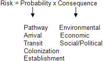
The team documented 35 aquatic nuisance species established in one basin with the possibility of transfer to the other. A risk assessment narrowed down the total to 13 species that have a high or medium risk for transfer with a likelihood of adverse impact if established in the opposite basin. Risk was calculated through the below equation.
After solidifying the list of ANS of Concern and their organism types, the team identified over 90 options and technologies available to control ANS transfer. Controls include those that modify flow within a waterway, such as hydrologic separation of the basins; those that modify the water quality of a waterway; collection and removal of ANS from a waterway; chemical application to ANS, as well as other types of controls currently in research and development. This list was refined through analyzing their completeness, effectiveness, efficiency and acceptability. Plans were then formulated and compared.
What types of alternatives are described in the GLMRIS Report?
The GLMRIS Report identifies eight Alternative Plans. Each of the eight plans utilizes one or more of these three strategies to reduce the risk of ANS transfer between basins: nonstructural controls; technological controls; and hydrologic separation.
- No New Federal Action – Sustained Activities
- Nonstructural Control Technologies
- Mid-System Control Technologies without a Buffer Zone
- Control Technologies with a Buffer Zone
- Lakefront Hydrologic Separation
- Mid-System Hydrologic Separation
- Mid-System Separation Cal-Sag Open Control Technologies with a Buffer Zone
- Mid-System Separation CSSC Open Control Technologies with a Buffer Zone
What are nonstructural controls?
Examples of nonstructural control measures include active management and removal of species (e.g., netting), chemical control (e.g., use of herbicides), controlled waterway use (e.g., inspection and cleaning of watercraft before or after entry to a water body), and educational programs. The Nonstructural Control Technologies Alternative evaluated measures that: can be implemented relatively quickly; protect human health and safety; require no construction; and have been implemented previously in North America.
What is hydrologic separation?
The GLMRIS Report defines hydrologic separation as, “the use of physical means to permanently separate two, or more, previously connected watersheds, in order to prevent the mixing of all untreated surface waters of the disconnected watersheds.” Some of the alternative plans in the GLMRIS Report include installation of physical barriers—made of concrete, sheetpile, earth fill, and other materials—in existing waterways. The physical barriers would stop the flow of surface waters and aquatic species between basins, and would be designed to control overtopping up to a 0.2% annual chance of exceedance (500-year) storm event. The physical barriers are also expected to impact flood risk, water quality, and navigation.
What technologies are proposed in the GLMRIS Report to control ANS transfer?
In the GLMRIS Report, more than 90 ANS control technologies were considered and screened for use in possible alternative plans. Four ANS control technologies were selected: the ‘GLMRIS’ (ANS Flushing) Lock; ANS Treatment Plant; Electrical Barrier; and Screened Sluice Gates. The GLMRIS Lock is a novel technology that would use ANS-treated water to flush floating plants, spores and eggs out of the lock chamber, while still allowing for vessel transportation through the waterway. The ANS Treatment Plant is similar to a conventional water/wastewater treatment plant process, where nuisance species would either be screened/filtered out or inactivated by ultraviolet radiation. Electric Barriers similar to those currently operating in Romeoville, IL would generate an electric field in the waterway to deter the passage of swimming fish. Screened sluice gates are proposed to exclude Great Lakes fish from swimming into the CAWS during backflow events.
How effective are each of the proposed ANS controls?
There is a varying level of uncertainty associated with the ability of each alternative to control ANS transfer through the CAWS; this uncertainty is further discussed in Appendix C of the GLMRIS Report.
The GLMRIS Report only addresses potential transfer of ANS through aquatic pathways. Other methods of transport, including animal (i.e. waterfowl) and human transfer may continue to pose a risk in the future.
There also is a risk that one or more presently identified ANS may transfer between the basins prior to alternative implementation. Nonetheless, these alternatives may also be effective at preventing the transfer of future ANS.
Could the alternative plans impact other uses or users of the waterways?
Lake Michigan and the CAWS support many functions, including commercial navigation, water supply, flood risk management, hydropower, recreation, and ecosystems. The ANS controls proposed in the GLMRIS Report are expected to impact many of these functions. The GLMRIS study expended great effort to examine the impacts of the Alternative Plans on waterway uses and users, and offer solutions to offset these impacts. The appendices of the GLMRIS Study Report offer a detailed look at expected impacts to: natural resources; navigation and regional economics; hydrology and hydraulics; and water quality. Each Alternative Plan also includes potential mitigation measures to offset the expected impacts. Mitigation measures include: ANS treatment plants; conveyance tunnels, reservoirs; and sediment remediation.
How much time would it take to implement the alternative plans?
Nonstructural measures could be implemented immediately; the Technology Alternative with a Buffer Zone could be implemented in 10 years; and all other alternatives could be implemented in 25 years. Full risk reduction would not be achieved until construction is complete. Construction of mitigation measures would be completed prior to or simultaneously with construction of ANS control measures. This schedule assumes that the project has a non-federal sponsor; receives capability funding; completes required lands acquisitions; obtains required permits; and is compliant with USACE policy requirements. Lastly, the schedule assumes conditional activities required by non-USACE parties are completed as necessary to facilitate timely completion of the project. A delay associated with any of these components would likely extend the time needed for project implementation and increase costs.
How much money would it take to implement the alternative plans?
Nonstructural measures are estimated to cost $68 million annually. Alternative Plans including structural measures are estimated to cost anywhere from $140 million to $220 million on an annual basis. Estimated costs for construction of the Alternative Plans including structural measures range from $8.3 billion to $18.3 billion. These costs are commensurate with the five percent level of detail in design for each alternative and may change with more detailed designs of an alternative.
Which alternative plan does USACE recommend?
The GLMRIS Report did not seek to make a recommendation or to rank the plans. USACE's role was to paint an objective picture of several alternatives and to offer decision makers and stakeholders with various potential ANS control methods and evaluation criteria.
How did USACE communicate the findings of the GLMRIS Report?
Upon release of the GLMRIS Report, USACE conducted an extensive engagement effort that included eleven public and eight state agency meetings, as well as briefings for congressional staff, Canadian stakeholders, regional organizations and local interest groups. A summary of the GLMRIS Report, the actual document and all of its appendices are available on this website.
How did USACE use public comments on the GLMRIS Report?
All public comments received, including transcripts of the public meetings, are posted on this website. The team generated a comment summary that includes information on the study; the public comment process; a summary of comments by location and themes; commenter demographic information; and USACE clarification on several recurring themes.
Input obtained from the public, agency partners, and other stakeholders during the comment period was utilized to help inform future decisions regarding opportunities for further study relating to GLMRIS. USACE continues to work with federal, state, and local governmental and regulatory agencies as well as with non-governmental stakeholders to participate in collaborative discussions and provide input or technical assistance in advising solutions to control the spread of ANS, as authorities and funding allow.
What did USACE hear from stakeholders and the public?
Among the general themes communicated in response to the GLMRIS Report: more than 98 percent of the individuals who submitted a comment expressed support for the need to control ANS; 40 percent favored an alternative that involved some type of physical separation; and 35 percent wanted an alternative that maintained current uses of the CAWS, predominantly focusing on navigation. Most of the commenters did not indicate a specific plan, however physical separation – alternative plans 5 and 6 in the GLMRIS Report – were mentioned most often at 12 percent.
Other ANS Efforts FAQ
Besides GLMRIS, what are the current efforts of USACE to prevent aquatic nuisance species (ANS) from establishing sustainable populations in the Great Lakes?
USACE supports the bi–national Asian Carp Regional Coordinating Committee’s (ACRCC) mission in preventing Asian carp, specifically bighead carp and silver carp, from becoming established in the Great Lakes through a four-part strategy:
(1) Constructing and operating electric barriers in the water outside of Chicago; (2) studying the effectiveness of the barriers and making adjustments, as necessary; (3) monitoring the waterways to determine abundance and location of the fish; and (4) conducting GLMRIS.
USACE is working tirelessly in the aquatic nuisance species and Asian carp fight and will continue to do so to protect our Great Lakes.
Details about projects and programs being undertaken by ACRCC member organizations in the U.S. and Canada are outlined in the Asian Carp Control Strategy Framework document available at http://asiancarp.us. The framework is updated annually. The ACRCC is comprised of various federal and state agencies with unique roles and responsibilities within the group. More information on USACE’s four–part strategy can be found at http://www.lrc.usace.army.mil.
How do the electric barriers work?
The electric barriers are just one control technology in the broad inter-agency effort to prevent Asian carp establishment in the Great Lakes. They are located about 37 miles downstream from Lake Michigan in the man-made Chicago Sanitary and Ship Canal. The Chicago Sanitary and Ship Canal connects the Chicago and Des Plaines Rivers, creating a continuous waterway connection between the Great Lakes and Mississippi River basins. It was completed in the early 20th century to address sanitation and flooding issues in Chicago, and accommodated increased shipping.
The electric barrier system includes the construction and operation of three electric barriers. The oldest barrier was originally built as a demonstration project. USACE has been authorized to upgrade and make permanent this demonstration barrier. Construction of the upgraded barrier is currently underway. The barriers are complex electrical and mechanical systems and must periodically be powered down for maintenance. Therefore, more than one barrier is needed so that at least one barrier can be active when work is being completed on other barriers.
Each barrier consists of steel electrodes that are secured to the bottom of the canal and connected to electrical equipment in an on–land control building. A low–voltage, pulsing DC current is sent through the electrodes, creating an electric field in the water. The electric field is uncomfortable for fish and deters them from swimming across it. The electric barriers do not block the flow of water or the movement of vessels, so the canal can continue to serve its intended purposes for conveyance of treated wastewater, stormwater management, and navigation.
Effective barrier operation is dependent on a proper combination of the frequency, length and amplitude of the DC pulses. USACE conducts studies and continues to monitor the Asian carp threat to ensure optimal settings. Each barrier built takes lessons learned from the previous ones to ensure the most effective deterrence tool possible.
Are the barriers effective?
USACE continually examines the effectiveness of the barriers through studies and monitoring. As discussed below, the ACRCC has an extensive Asian carp monitoring program and no Asian carp have been captured above the barriers toward Lake Michigan other than a single one in summer 2010. In addition, USACE has an ongoing program to track tagged fish via an acoustic network with receivers throughout the CAWS. To date 440 fish have been tagged and results confirm that, when activated, the barriers are an effective deterrent to upstream passage. Other testing is ongoing to examine the effectiveness of the barriers on very small fish and the potential impacts of vessel traffic on effectiveness. USACE continues to work with their partners and stakeholders to assess the Asian carp threat and make informed decisions regarding barrier operations.
Where are the carp?
The inter–agency ACRCC Monitoring and Response Work Group has documented adult Asian carp in the Des Plaines River about 18 miles downstream of the electric barriers and 55 miles from Lake Michigan and considers this location the leading edge of adult Asian carp in the Illinois Waterway. This leading edge has not changed for the past seven years. No small Asian carp have been observed closer than 131 miles from Lake Michigan. The monitoring for Asian carp and the continued removal of adult species near the leading edge is a top priority of the ACRCC.
The latest monitoring information is available at http://www.asiancarp.us
How does USACE monitor the location of Asian carp?
USACE works with other agencies as a part of the ACRCC Monitoring and Response Work Group to monitor the CAWS to help determine the location and abundance of Asian carp in the area and to also analyze the effectiveness of the electric barriers.
Methods include traditional netting, electrofishing from a boat, collecting water samples for DNA, tracking tagged fish through receivers (telemetry), and use of acoustic cameras (Dual–Frequency Identification Sonar, or DIDSON) to view real–time fish behavior in response to the barriers’ electrical field.
USACE will continue to work collaboratively to apply the best science, data and facts available to constantly improve the collective Asian carp monitoring effort.
What is eDNA, and how is USACE using it?
Environmental DNA (eDNA) is a process used by the ACRCC in which genetic material is extracted from water samples to help inform decisions related to preventing Asian carp transfer. Fish, including Asian carp, release cells containing DNA into the environment from many sources including mucus, feces, and urine. The DNA degrades in the environment, but this process is not instantaneous, and DNA can be held in suspension and transported. eDNA evidence complements the use of other monitoring tools.
A positive water sample certainly could mean a live Asian carp, but as demonstrated through several lab and field studies, there are several other ways DNA can get into the water: bird fecal material, fishing gear (boats and nets), and hulls of vessels that travel from areas with high numbers of Asian carp. Once we know how DNA can get in the water, we can begin to correlate certain positive indications with the environment and look into mitigating other sources beyond a live fish.
The Corps led an interagency eDNA Calibration Study (ECALS) with U.S. Geological Survey and U.S. Fish and Wildlife Service to reduce the uncertainty surrounding eDNA results and further refine the eDNA method. ECALS investigated possible alternate sources of Asian carp DNA (other than live fish), methods to improve existing genetic markers, and the relationship between the number and distribution of positive eDNA samples and the density of Asian carp populations. The first interim ECALS report was released in March 2013. The study is scheduled for completion in 2014.
The results of ECALS will provide more context for interpretation of eDNA results and identify ways to make the eDNA sampling process more efficient through decreased processing time and reduced costs. When results in the CAWS indicate positive detections for Asian carp eDNA, yet hundreds of hours of netting and electrofishing turn up no actual fish, there is the ecological and fiscal responsibility and duty to determine what the sources beyond a live fish could potentially be. The ECALS Team wants to arm scientists with the best monitoring tool possible.
The eDNA sampling program (actual collection and processing of water samples) is led by the U.S. Fish and Wildlife Service’s Whitney Genetics Laboratory in Onalaska, Wisconsin.